We developed a software with the aim to realize:
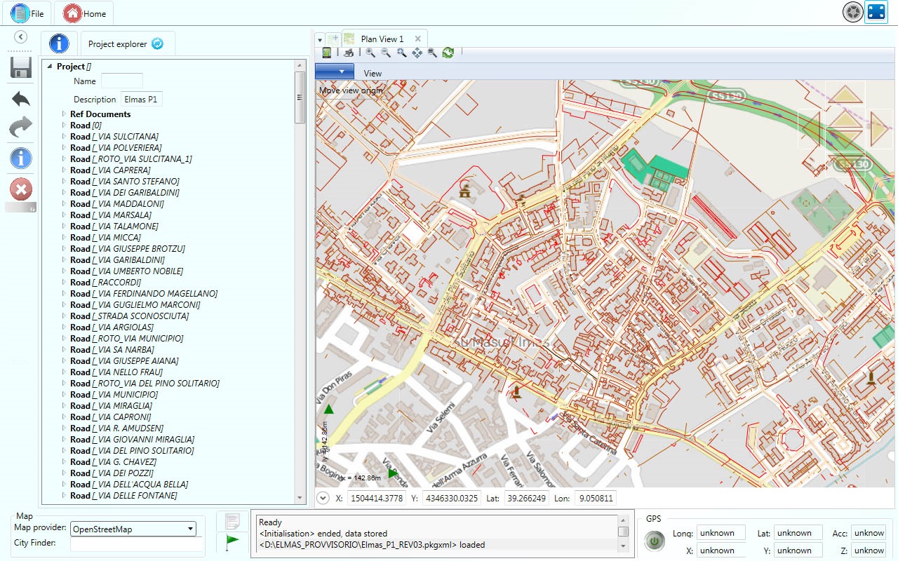
- the geo-localised cataloguing of public assets and its deteriorations, in particular the management of Road Cadastre database;
- the budget quantification (budget summary) for ordinary and extraordinary maintenance;
- the monitoring of assets maintenance and wear condition;
- the document management of processes in accordance with ISO 9001:2015 standard;
- the decision support to the management of public assets.
Its main characteristics are:
- easy to use - thanks to the tablet with integrated GPS, the graphic interface allows to have a complete picture of the context in which we move, acquire information, simulate the effects of interventions, record activities and then identify the critical points and study their solutions;
- flexibility - developed to meet the needs of both administrators and operators in the field;
- modularity - the software is organized in modules which cover all the elements related to the management of infrastructures;
- economic - characteristics and cost of the provided package will be customized according to operational needs
The software PKBIM has no association with the external majors (Autodesk®, Bentley®, MapInfo®, ESRI®, Oracle®, etc.), it works without need for any other drawing software or data base. The software has been developed on graphics support in c# language, created specifically for programming in .NET Framework, with graphical interface WPF (Windows Presentation Foundation).
The display is managed directly by the graphics processor, which is faster, working directly with the memory of the graphics card.
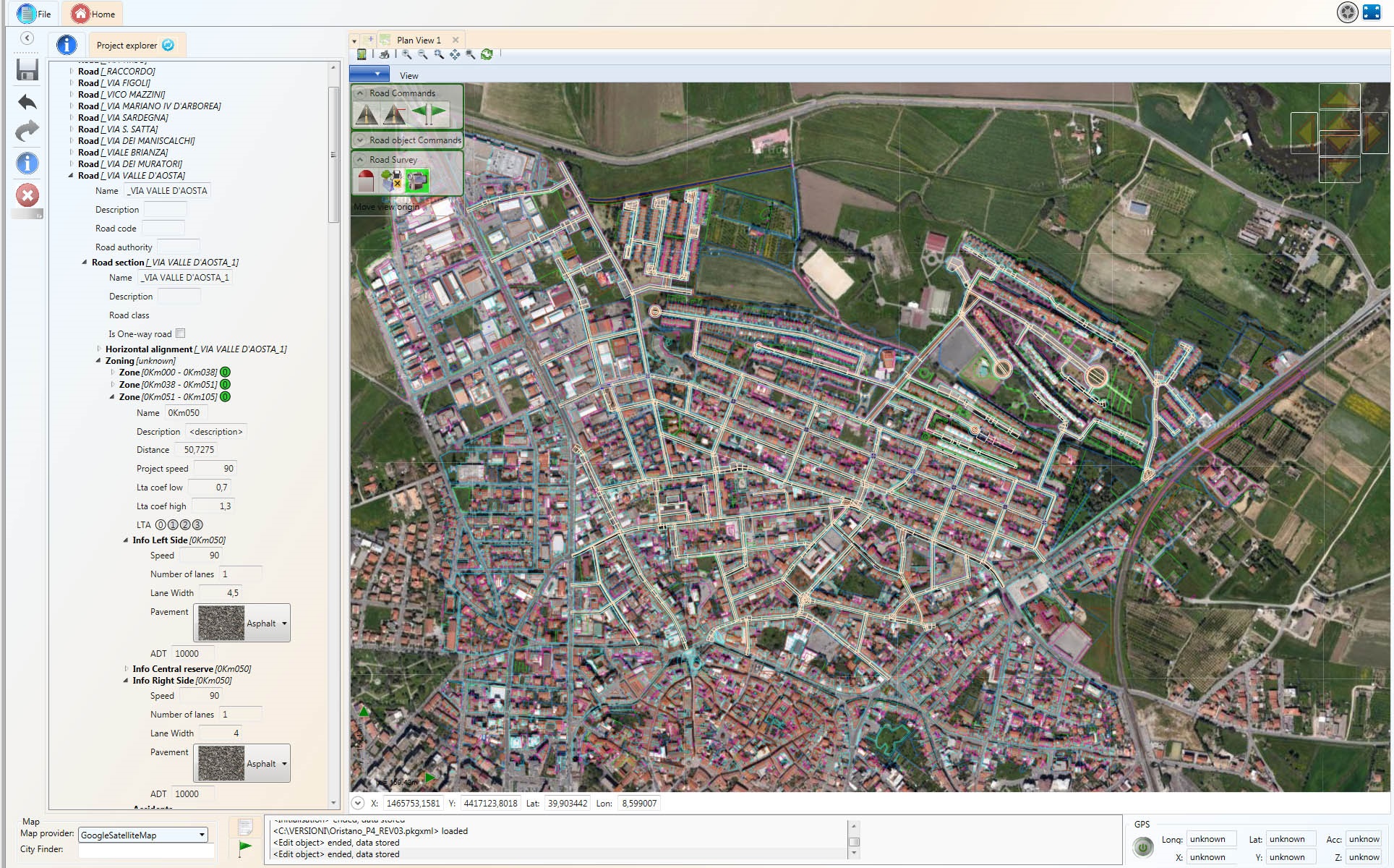
The tool allows to manage a wide range of information: road pavement, bridges, viaducts and subways, tunnels and overbridges, margin gutters, balks or embankments, street lighting systems, parking areas, guardrails, road service areas, hydraulic works, driveways, milestones, black points, technological networks, road surface degradation, road signs, advertising panels, etc.
The software, with reference to the arguments provided by the Road Cadastre, is organized into different modules:
- MODULE FOR GEOMETRIZATION
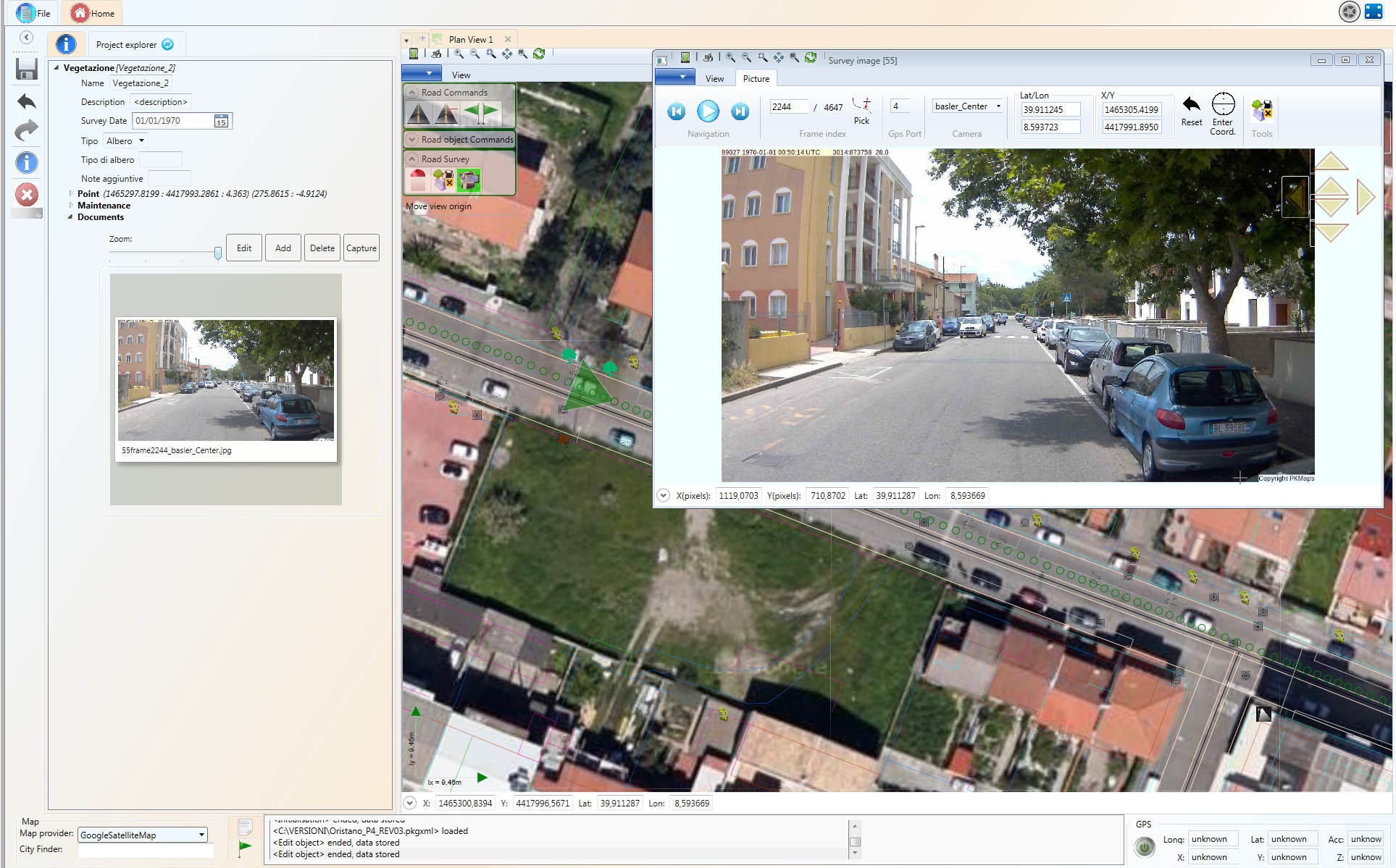
The software PKmaps V3 is a tool that allows the user to work on road layouts surveys that were detected with the instruments Box-Video and Mini-Box.
Once the georeferenced frames are loaded, it is possible to quickly geometrize all objects related to road infrastructure directly from the images.
Thanks to this tool it is possible to speed the process of Road Cadastre realization, also allowing viewing in real time what has been achieved.
- MODULE FOR MANAGEMENT OF MAINTENANCE
Road signs
It is used to manage vertical signs, horizontal signs, traffic light systems, variable message boards.
In particular for the vertical signs it is possible to display the detected panels, the description of their technical characteristics and to finally manage their priorities of maintenance interventions. The analysis is performed both for the individual panels and for the support through specific check-lists, which allow obtaining an evaluation of the degradation both individually and globally.
Civil engineering works
The module includes a great variety of works among which bridges, overpasses, tunnels, ditches, manhole covers , road protection, hydraulic structures, etc.
In particular the bridges module allows evaluating the state of the work using a visual method that takes into account each individual structure element, the strategic importance of the construction, the importance of the road network and the actual deteriorating state of the work.
Road furniture
The objects managed through this module are safety barriers, traffic measurers, street lighting, green spaces, vegetation, etc.
In particular the module for guard-rails management arose from the need to know the actual state of crash barrier with the aim of improving road safety, it was therefore necessary to create a method for calculating the priority of interventions based on elements state and road conditions (Ro.Sa.Ma.S. Project - Provincia di Pisa, Servizio Viabilità).
This method, together with the possibility to import into the software the related price list, allows to obtain easily and immediately an estimation of costs to be incurred for priority interventions.
Urban decor
This is the module that allows to place and manage all objects present in urban areas (for example: fire column, telephone antenna, bus stop, etc.); for each object there is a specific check-list which allows to determine the intervention priorities.
Degradation of road surface
This module allows, in function of the type of surface present along road infrastructure (concrete, asphalt, cobblestone and ground), to visually identify the type of degradation and to subsequently evaluate the intervention priority. Priority can be calculated using different methods, such as PCI evaluation method (Pavement Condition Index - American Regulation D6433-11).
- MODULE FOR MANAGEMENT OF TAXATION
The module allows managing advertising installations and taxable surfaces (accesses, occupation of public land, terraces, etc.), in particular with regard to:
- advertising installations: the management of advertising billboards allows to associate information in order to obtain as output the value of taxation, with any possible specifications about contract expiry, number of renewals, etc. Taxation methods present in the software PKmaps V3 refer to national legislation (D.L. n° 507 dtd 15th November 1993 and subsequent amendments) and to ANAS technical specifications (based on D.L. n° 285 dtd 30th April 1992). It is always possible to implement other taxation methods.
- taxable surfaces: similarly to what was done in the module for advertising billboards, we can associate to areal, linear or punctual elements the information needed to identify surfaces, whether they are access, occupation of public land, terraces, etc.
Taxation methods make always reference to national legislation and allow a periodic control on the basis of the reference name, the square meters of surface to be taxed and the amount to be paid; it is always possible to implement other taxation methods.
- MODULE FOR MANAGEMENT OF ACCIDENTS
The module for management of accidents is the tool to store, analyse and display all road traffic accidents through the software PKmaps V3.
The presence of the main compilation fields to describe an accident, following the structure given by ISTAT, together with the road conditions, that are determined through the other modules of the software Pkmaps V3, can finally provide clarity about the localization of most dangerous areas (black points) existing along road infrastructure.
The module was created as a method of statistical evaluation of accidents on road infrastructure and it was then expanded with the addition of all information useful for an accident survey in the fields.
This allows, according to user permissions, to process only purely informative data (type of accidents, number of involved vehicles, number of involved people), or to view all the information concerning the accident (name of involved people, numbers of license plate, etc.). This distinction is closely related to the permissions that the user has.
Through this module it is also possible to import some file formats from existing databases, such as the one of SIRSS Project (Regione Toscana).
- MODULE FOR ANALYSIS OF ROAD LAYOUT
PKmaps V3 is the evolution of a software that has changed some features over time: the graphic engine has been improved, the basic geometry has been modified (using elements present in the road geometry) and a module has been added, this new module allows analysing road layout in accordance with current legislation. The user can therefore know which road sections are in violation of regulations in terms of incorrect geometry, sight distance or travel speed. A synoptic diagram is provided, as well as xml files with the results, that can also be managed with excel in order to allow the user to analyse the data with different instrumentation.
.
From
HERE you can access some videos that explain the software and other applications